
Distance | 3½ miles (5.6km) |
Minimum time | 2½ hours |
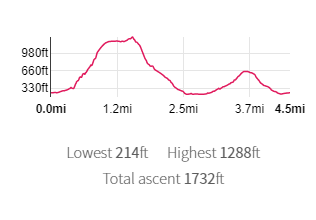
Total ascent | 1,296 ft (395m) |
Level of difficulty | Challenging |
Paths | Footpaths but with steep climbs, 1 stile |
Map | OS Explorer OL7 |
Start/finish | Grid NY 32696 05169 |
Dogs? | Not recommended |
Parking | Langdale Estate / Off B5343 |
Public Transport | Bus - 516 Langdale Rambler - nearest stop Elterwater, 1½ miles |
Toilets/Refreshments | Langdale Estate / Grasmere Village |

Leave the Langdale Estate by Fellside gate and turn left along the B5343 road.
Turn right down a public footpath after a cottage named Beckfoot. If you're not staying at the Langdale Estate, car parking is off road here.
The footpath rises gently along the side of a stream before meeting a minor road.
Pass through the gate, turn left and then right just after the 20mph sign.
The path climbs steeply up the fellside with a small beck and a wall on the right. Climbing further, the stream and the wall fall away.
After a slight leveling of the path, it heads rightwards to follow the edge of the gorge of Meg Gill.
Care is needed here as steep slopes lead down to the river on the right.
More inclines are had until the path eventually fords the Gill.
The path now continues rightwards across the fellside at a gentle gradient.
It then veers left and rises more shrarply to access a grassy slope leading to a large, low cairn - the meeting point of five paths.
Take the path straight on (like the second exit on a road roundabout) which veers left and climbs steeply to the top of the ridge where a large cairn is waiting.
Walk forwards until a small water channel blocks the way. Cross this on the right and veer north-northeast on a faint track towards the summit of Silver Howe.
Descend steeply by a path marked with cairns on the northern side of the summit.
Ford the juniper and birch-lined channel of Wray Gill and descend further through thicker areas of juniper.
At the bottom, turn right and the unusual sight of a stone wall is to the right.
Follow this path, which doubles as a water course and eventually head right towards the gate leading to the first paved path for several miles.
Head down this path until the it meets the road. Turn right and head away from Grasmere.
Eventually head along the road rising to the right and through the various gates into Hammerscarr Plantation.
Follow the path until it meets the minor road and follow the road to the right.
When the road splits, take the left down the steady slope.
A right at the junction with the main B5343 will bring the Langdale Estate back into view on the left.
We'll be putting more relevant links here soon.
If you've got a link you'd like us to include, e-mail us here.