Walks from Season Three - Ningwood to Yarmouth
The full Isle of Wight Coastal Path is a 67 mile trek all around the island... but there are fantastic short walks taking in parts of the Coast Path, like this one. Starting from Ningwood inland, the walk joins the Coastal Path all the way to the harbour town of Yarmouth.
If you've done this walk, we'd love to see your photos and videos. Share them with us on Twitter, Facebook or Instagram.
The full walk is available to watch on Walks Around Britain+, our "Netflix for Walking" video subscription website - click here for a 7 day free trial.
A walk from Ningwood to Yarmouth on the Isle of Wight - Walks Around Britain Shorts


Route Directions
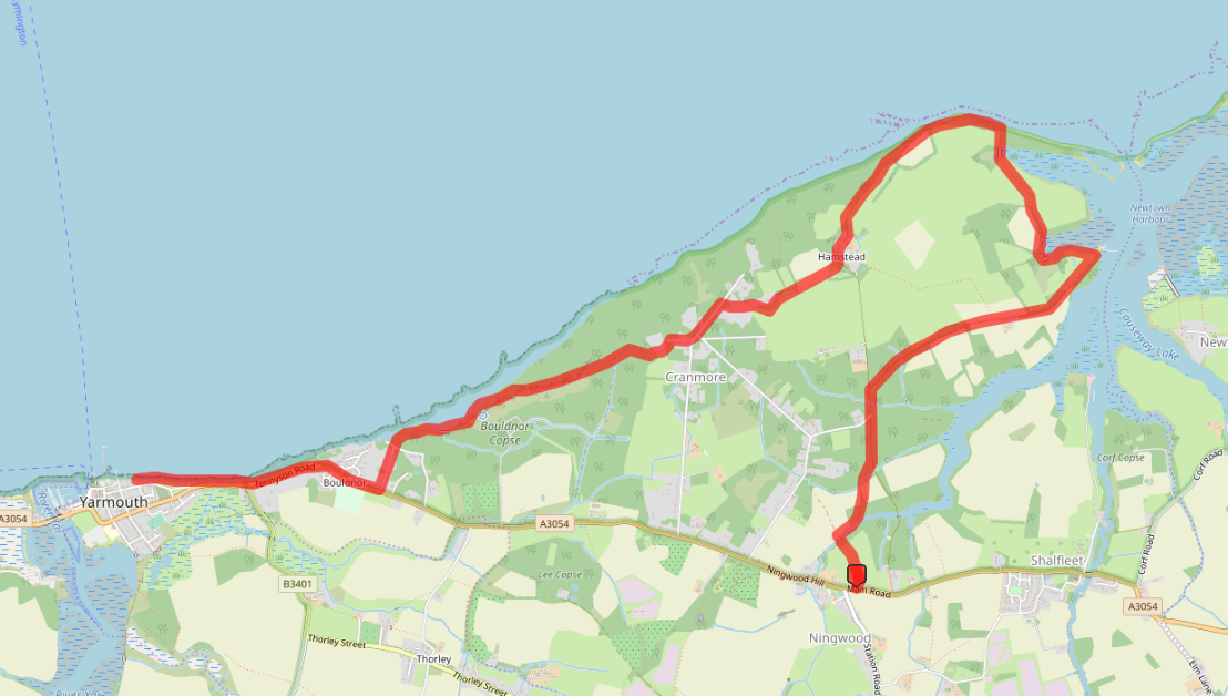
- The walk starts from the public footpath between the car park and the Horse & Groom pub – just on the A3054. If you are arriving by bus, get off at either of the “Horse & Groom” bus stops.
- All of the footpaths on the Isle of Wight are numbered, and have a letter to show the parish it is in, so this footpath number 9 in the parish of Shelfleet – and is heading towards Cranmore.
- Follow the path as it turns to the right, climb over the stile, and turn left to walk along a field with a row of hedges on the left.
- In the far corner of the field, cross over the stile, head through a wooded section and cross Ningwood Lake via the bridge – climbing over the stile at the far side.
- The footpath turns right here, to follow the lake for a while, before turning gently left after it has entered a wood.
- Once out of the wood, the footpath crosses a field diagonally before re-entering another wood. The path joins the Isle of Wight Coastal Path in the middle of the wood. Turn left here, along path S27.
- Carry on along this fairly straight path until a major path branches out from the right. Take this path, which is signposted “Coastal Footpath and Hamstead Trail” – path S28. The Hamstead Trail, which is a seven mile walk from north to south of the island.
- Follow the path, and looking right will give you glimpses of Newtown River. Soon, a metal gate appears to block the way, but there’s an open passage on the left for walkers.
- The path goes all the way down to the jetty on the shores of the Newtown River. After exploring this area, double back on yourself, and turn right – following the Coastal Path signs.
- This whole area was saved in the 1960s from the threat of a nuclear power station being built in the harbour entrance, mainly thanks to the efforts of local people conducting wildlife surveys which proved just how special this place is.
- The paths turn into wooden boardwalks in places here over the top of some of the more muddy sections. After a bit of field walking, the walk heads out onto more boardwalks across large areas of marshlands.
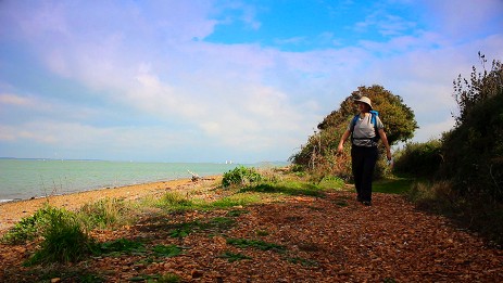
- Following the signs, the Coastal Path emerges from some tree cover onto the beach at Hamstead Point. Turn left here, and walk along the beach, before the path rises up on the top of Hamstead Cliff. Be a little bit careful of your footings around here.
- The coast disappears behind woodland before arriving at the side of Hamstead Farm. Climb the stile and turn right, following the made path around the farm, until the Coastal Path takes a right. Walk around the big metal gate and follow the path S3 across the open field.
- At the far side, climb the stile and turn left. The path skirts around West Hamstead Farm here, and eventually reaches Sea View Road. Turn left, and after a while, the Coastal Path signs will take you right and then into Bouldnor Copse – with the Bouldnor Cliff on your right.
- After opening out on to the coast a for short while, the Coastal Path turns inward and heads down Victoria Road to meet the main A3054 Tennyson Road.
- Careful cross the road here, and turn right – walking on the grass verge and following the A3054 until the path crosses over to finish on Yarmouth Green.
- To head back to Ningwood, there’s a bus stop for service 7 on the A3054 Tennyson Road just near the junction with High Street.
Print these directions
Walk Info
Distance | 7 miles (11.3 km) |
Minimum time | 3½ hours |
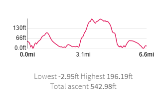
Total ascent | 543 ft (166m) |
Level of difficulty | Easy |
Paths | Public footpaths 3 gates / 6 stile |
Map | |
Start/finish | Grid SZ 40089 89188 |
Dogs? | Keep on leads |
Parking | Pay & Display Car Park |
Public Transport | Bus |
Toilets/Refreshments | In |
Gradient Profile

Share this walk
Relevant Links
![]()
We travelled to the Isle of Wight on Wightlink Ferries, and they have some great information about walking on the island on their website.
Visit Isle of Wight - Walking
Information about walking on the Isle of Wight from the official tourist board.
- Get free entry to over 500 special places
- Free parking at most National Trust car parks
- National Trust Handbook full of ideas to help you plan a visit
- National Trust Magazine sent to you three times a year
And only £9.55 a month for a 2-adult family via Direct Debit
If you enjoyed this walk, you might like these...