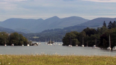
Walks from Season One - Windermere and Claife Heights
A 3 mile easy walk along the west shore of Windermere and then up through the Claife Heights to the Victorian viewing point of Claife Station on National Trust land.
If you've done this walk, we'd love to see your photos and videos. Share them with us on Twitter, Facebook or Instagram.
The full walk is available to watch on Walks Around Britain+, our "Netflix for Walking" video subscription website - click here for a 7 day free trial.


A walk along Windermere through Claife Heights - Walks Around Britain Shorts
Walk Info
Distance | 3 miles (4.8km) |
Minimum time | 1¾ hours |
Total ascent | 328 ft (100m) |
Level of difficulty | Easy |
Paths | Well defined paths & permitted route - gentle rise 4 gates |
Map | |
Start/finish | Grid SD 3970 9582 |
Dogs? | On leads |
Parking | Pay And Display Car Park off B5285 |
Public Transport | Bus - 517 - Windermere to Patterdale |
Toilets/Refreshments | In Bowness |

Share this walk
Route Directions
- Start the walk from the landing stage at Far Sawrey on west side of Windermere lake.
- With the landing stage behind, walk along the B5285 and follow it around as it bends until a wooden public footpath sign points to the right.
- Walk through the gate and continue on the path around as it the right as it follows the line of Mitchell Wyke Ferry Bay.
- The path joins a road path which enters the National Trust's Claife Estate.
- If you want to walk along the shoreline, then leave the road after the path emerges from the trees.
- Follow either the shoreline or the road path until the you come to a gate on the road path.
- Go through the gate, and turn to walk up the first path on the left.
- This starts to climb steadily into Belt Ash Coppice.
- On the left will be views of Windermere through the trees.
- After climbing up, a path on the left signposted for Far Sawrey appears.
- Go through the kissing gate and steadily start to decend.
- Station Scar Wood is on the left and Mitchell Knotts on the right.
- Follow the footpath as it continues to decend, eventually getting steeper as you get nearer to the water of Windermere.
- Soon, you walk past the Claife Viewing Station, owned by the National Trust - which is worth a look.
- Continue to follow the footpath down, and it reaches the B5285 through a small gap in the stone wall.
- Turn left and walk along the B5285, taking care with traffic coming behind you.
- Follow the road around the bend to the right, past the ferry charges sign and round past the gate you walked through at the start.
Print this page
Relevant Links
Beech Hill Hotel - High Biggin Luxury Holiday Home
Where we stayed for our walk - the Beech Hill Hotel's fantastic luxury holiday home.
Where we stayed for our walk - the Beech Hill Hotel's fantastic luxury holiday home.
Lake District National Park - Exploring Windermere
Information about visiting the Windermere area from the National Park![]() Join the National Trust
Join the National Trust
- Get free entry to over 500 special places
- Free parking at most National Trust car parks
- National Trust Handbook full of ideas to help you plan a visit
- National Trust Magazine sent to you three times a year
And only £10.50 a month for a 2-adult family via Direct Debit
If you enjoyed this walk, you might like these...