Walks from Season Two - Bowness to Brant Fell
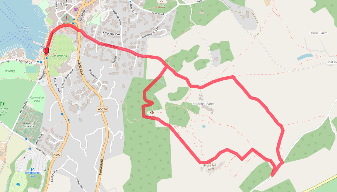
A 2 mile walk from the beautiful town of Bowness, along a short part of The Dales Way, to the easy summit of Brant Fell - with its splendid views of Windermere and the surrounding fells.
To keep up to date with us, follow us on Twitter - WalksBritain
The full walk is available to watch on Walks Around Britain+, our "Netflix for Walking" video subscription website - click here for a 7 day free trial.


A walk from Bowness to Brant Fell in the Lake District - Walks Around Britain Shorts
Walk Info
Distance | 2 miles (3.2km) |
Minimum time | 1½ hours |
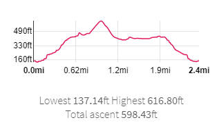
Total ascent | 599 ft (183m) |
Level of difficulty | Medium |
Paths | Pavement, grassy paths 2 stiles |
Map | |
Start/finish | Grid SD 40344 96966 |
Dogs? | On leads |
Parking | Pay & Display Car Park on Glebe Road |
Public Transport | Bus - 555 between Kendal & Keswick |
Toilets/Refreshments | At Car Park / Bowness centre |
Gradient Profile

Share this walk
Route Directions
- If you’re arriving in Bowness by car, park in the pay and display car park on Glebe Road, and walk past the marina and the National Park Information Centre to get to the main A592 road.
- If you’re arriving by bus, there are bus stops on either side of the A592 near the National Park Information Centre.
- With the lake on your left, head along the A592 Promenade, and at the pelican crossing make your way to the other side of the road, and turn left.
- The road turns right and starts its climb into the town centre.
- Just as you see St Martin’s Church on the left, take the road on the right – St Martin’s Place.
- At the crossroads, go straight ahead to walk along Brantfell Road.
- Here, you’ll pass the “official finishing pub for the Dalesway” – The Royal Oak.
- Continue climbing and ignore all roads off Brantfell Road, until the road gives way to a public footpath.
- Carry on along this footpath until you reach a crossroad of paths. The Dales Way continues straight on – all the way to Ilkley… but this walk turns right.
- Soon, the path enters a woodland area, before emerging, where a detour on the right will take you to the vantage point of Post Knott.
- After a look here, turn left and follow the path as it drops down slightly, before crossing a ladder stile and then rising up again.
- There isn’t a specific footpath to the top of Brant Fell, but placed rocks on the ground signpost the allowed route to the summit.
- The summit of Brant Fell once had a Victorian viewing station placed on it – the two posts visible are now the only remains of the structure – but outlasting it are the truly awe inspiring views of the area.
- Now, either return the same way, or continue down Brant Fell with the lake behind you, to meet the public footpath – and then turn right.
- The footpath brings you out onto Lindeth Lane down a track. Turn a sharp left here to walk along Lindeth Lane – but not for long, as you take the next left footpath, highlighted by a wooden stick-type sign.
- Go through the gate, and follow the footpath past a woodland on the right, to eventually join up with The Dales Way.
- Turn left here to follow the The Dales Way back to the crossroads of paths you turned right at earlier.
- Carry straight on here and retrace your steps back to the car park or the bus stop.
Relevant Links
Beech Hill Hotel - High Biggin Luxury Holiday Home
Where we stayed for our walk - the Beech Hill Hotel's fantastic luxury holiday home.
Where we stayed for our walk - the Beech Hill Hotel's fantastic luxury holiday home.
Lake District National Park - Exploring Windermere
Information about visiting the Windermere area from the National Park
Information about visiting the Windermere area from the National Park
The website from the Dales Way Association who look after the route.
If you enjoyed this walk, you might like these...